
Summary
For those of you living in New York City, but are interested in taking a hiking trip out of the city, the Appalachian Trail is closer than you think. There are a number of fantastic hikes (both single and multi-day trips) along the trail which can all be reached via the Metro-North train network.

Beautiful view from a rock in the MIDDLE of the Housatonic River.
Below I have outlined everything you need to know to take a two-day weekend trip along the Appalachian Trail. If you are more interested in one-day hikes, check out my other guides to Breakneck Ridge and Nuclear Lake. Alternatively, since this is a hike-and-return trip, you can follow the same path, but cut the distance in half.
This guide is was created after my weekend trip along the trail. If you would like to read more about my travels check out my Return to the Appalachian Trail post.
Getting There
By Train
The conveniently named Appalachian Trail Station is located about 2 hours north of Manhattan. To get there, hop on the Harlem Metro-North Line (the one in blue) and it will take you to the Appalachian Trail Station.
-
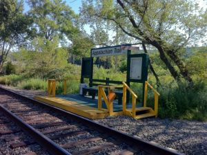
My favorite little train station.

You will need to transfer at the Southeast Station, but it is relatively simple and the trains are well timed. The train you are looking for is very old and surprisingly loud, so I sincerely doubt you’ll miss it. If you are concerned, ask a conductor or simply follow the other backpackers.
There are a few important facts that you should take note of:
- The Harlem Line only stops at the Appalachian Trail Station on Saturdays and Sundays (and holidays)
- Only 4 trains stop at the Appalachian Trail Station each day
- 2 Northbound trains in the AM
- 2 Southbound trains in the PM
- Only the rear doors of the very last car open at the station
- Searching Google Maps for the Appalachian Trail Station will bring up a different station than the one you want (see picture below)
-
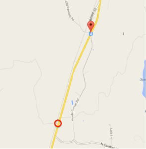
The marker at the top is where Google Maps says the stop is and the red circle is where the stop actually is.
- You can check out the MTA website for the most up to date train schedule.

When you arrive at the Appalachian Trail Station, make your way to the Route 22 (you will see the road in front of you when you exit the train) and follow it North for about 500 feet. Continue past the Native Landscapes Garden Center, the trailhead will be on the right. Look for the white “AT” symbol indicating the Appalachian Trail.

The typical AT symbol indicating the Appalachian Trail (or Andrew Tello). Personally I prefer the latter.
By Car
If you are lucky enough to have a car, the drive up should take about an hour and a half. The best place to park is about a quarter of a mile north of the trailhead. There are two small parking lots on either side of the road with plenty of spots to park. If you want exact driving directions here’s a link to Google Maps.
Once you arrive, walk South along Route 22 for 200 feet and you will see the trailhead on your left.

It doesn’t matter how far you hike along the trail, the remanence of civilization are all around…
The Hike
- Difficulty: 5/ 10
- Distance: varies (see below)
- Elevation Gain: ~1,000 feet
- Time: ~14 hours*
The trail itself is remarkably easy to navigate. From the Appalachian Trail Station, simply follow the White blazes indicating the Appalachian Trail until you reach the shelter of your choice. Overall, the shelters are fairly well spread out, clean and are all equipped with a lean-to, privy (a.k.a. outhouse), and running water. From the Appalachian Trail Station you have three options:
- Wiley Shelter (~6 miles from the train station)
- Ten Mile River Shelter (~10 miles from the train station)
- Mount Algo Shelter (~18 miles from the train station)
Below is a map which outlines the Appalachian Trail in red and the location of each shelter listed above.

Quick reference map of shelters along the Appalachian Trail.
The trail itself is relatively flat and consists primarily of rolling hills. Arguably the most difficult section of will be hiking up/down Ten Mile Hill which is located immediately South of the Ten Mile River Shelter. Overall, this is an excellent trip for hikers of all experience levels since it is possible for the hiker(s) to adjust the total distance of the trip based on the shelter they want to reach.
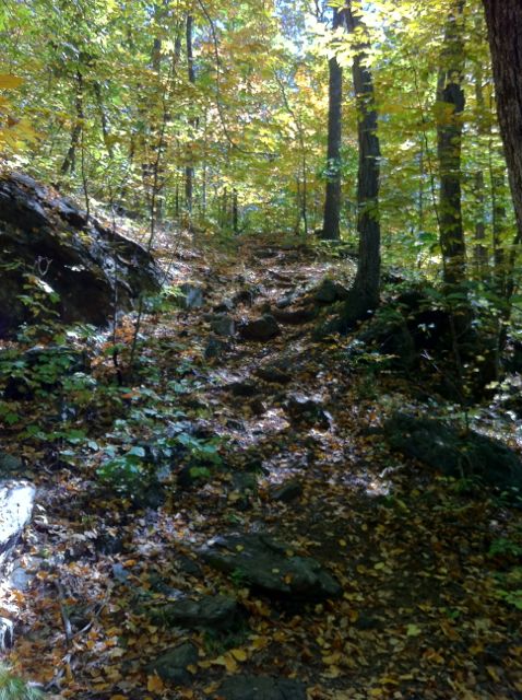
The trees and the light create a picturesque hike through the Appalachian Train
While you will cross some beautiful fields and rivers along the trip, there are no scenic hilltop vistas along this section of the trail. If you are interested in a nice view during your hike, it is recommended that you walk South from the Appalachian Trail Station toward Nuclear Lake.
Definitely a nice change of pace from the streets of Manhattan.
*the time quoted is actual hiking time; if you’re traveling in a group make sure to add extra time
Getting Home
Since this is a hike-and-return type of trip, you will end up back at the Appalachian Trail Station where you began. As long as you time out your hike, you should have no issue catching the train back to Grand Central. Before you leave on your trip check the MTA website for the most up to date train schedule back into the city.

View of the Housatonic from along the river’s edge.
Trip Cost
For my trip in September 2013 I spent a total of $90.45*, here is the breakdown:
- Round Trip Subway Fare to Grand Central: $5.00
- Round Trip Train Ticket to Breakneck Ridge: $30.50
- Supplies: $24.00 (2x trail mix packs; 4x Clif Bars; 1x pack of dried fruit)
- Tent: $38.00**
- Iodine Tablets: $11.95

This is happiness.
Note: this is definitely on the lower side and if you need to buy any hiking equipment or plan on doing other activities during/after the hike you will need to add it to amount quoted above.
*I also brought $40 cash with me just in case.
**The total cost of the tent was split between two people.
What You Need
Overall you can do this hike with minimal equipment and some common sense. Here’s what I brought on my hike in September 2013:
- Standard Backpack (nothing special, I’ve had it for >6 years)
- Standard Sneakers (hiking boots are preferable, but not required)
- 2L Camelbak (2+ liters needed per person per day)
- Iodine Tablets (REQUIRED – you will need to refill on water during the trip)
- Standard Two-Person Tent
- Supplies (trail mix, nuts, clif bars – anything light and energy dense)
- Toilet Paper (this should be a REQUIRED item)
- Cell Phone
- Map (printed and on my phone)
- Extra Cash

The better question is, “Why NOT take a karate picture?”
Other Optional Items
- Book (in case you have to wait by yourself for the trains)
- Bandaids (you never know…)
- Sunscreen (much of the trail was covered with trees; bring if you burn easily or hike during the fall/winter)
- Sunglasses
- Camera (I used my cell phone)
- Compass (If you are prone to getting lost)
Tips & Resources
- Bring at least 2 liters of water per person; even on cool days, you will be surprised how quickly you go through water
- Bring extra snacks if possible, there’s no better way to make new friends 🙂
- Other great resources for information on the Appalachian Trail and Nuclear Lake

Interesting little flower, looks like it’s made of ribbons.

Andrew, this is a great post! Do you have any other recommendations for a day trip for fit but novice hikers?
Thanks so much! If you are looking for a more challenging (but exciting) hike, I recommend Breakneck Ridge. There are a number of different routes you can take in the area depending on how far you want to hike. Check out my Breakneck guide for everything you need to plan your trip.